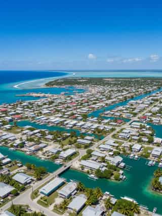
South Tarawa - The Capital of Kiribati
- Population
- 63,439
- Language
- English
- Continent
- Oceania
- Since
- 1979
- Eco Ranking
- 97/195
Source: Environmental Performance Index 2024.
About South Tarawa
South Tarawa is the capital of Kiribati (pronounced 'Kiribas'), a Pacific island nation that gained independence from Britain on 12 July 1979. The capital is not a single island but a chain of islets connected by causeways on the southern part of Tarawa Atoll. Kiribati is among the countries most acutely threatened by sea-level rise: South Tarawa sits at an average elevation of barely 2 metres above sea level, and much of the country's land is at risk of inundation as global temperatures rise. The Kiribati government purchased 20 square kilometres of land on the Fijian island of Vanua Levu as a potential future relocation site. Kiribati spans three time zones and straddles the equator, making it geographically unique. During World War II, Tarawa Atoll was the site of the Battle of Tarawa (November 1943), one of the bloodiest battles in US Marine Corps history, in which over 1,000 American and nearly 4,500 Japanese and Korean labourers and soldiers died in 76 hours of fighting.
About Kiribati
Kiribati is a presidential republic in which the president (Beretitenti) is both head of state and head of government, elected by popular vote. The country consists of 33 atolls and reef islands spread across 3.5 million square kilometres of the central Pacific Ocean. Kiribati is one of the world's most geographically dispersed nations and faces an existential threat from climate change and sea-level rise.
View South Tarawa on the map
Flight time from South Tarawa to other capitals
| City | Distance (km) | Flight Time |
|---|---|---|
| Canberra | 4800 | 5h 39m |
| Tokyo | 5100 | 6h 0m |
| Singapore | 7700 | 9h 4m |
| Washington, D.C. | 11600 | 13h 39m |
| Abu Dhabi | 12800 | 15h 4m |
| Buenos Aires | 13500 | 15h 53m |
| London | 14100 | 16h 35m |
| Paris | 14400 | 16h 56m |
| Rome | 14800 | 17h 25m |
| Cape Town | 15500 | 18h 14m |
Capitals with similar population to South Tarawa
Capitals with similar eco ranking to South Tarawa
| City | Eco Rank |
|---|---|
| Yerevan | 94 |
| Port Vila | 95 |
| Kuwait City | 96 |
| South Tarawa | 97 |
| Mexico City | 98 |
| Montevideo | 99 |
| Windhoek | 100 |
Source: Environmental Performance Index 2024.
Frequently Asked Questions
Why is Kiribati threatened by climate change?
Kiribati consists of low-lying atolls with an average elevation of approximately 2 metres above sea level. As global sea levels rise due to climate change, much of Kiribati's land area is at risk of becoming uninhabitable due to flooding, saltwater intrusion into freshwater supplies, and erosion. The government has purchased land in Fiji as a potential relocation site and has engaged in international climate diplomacy to press for emissions reductions.
When did Kiribati gain independence?
Kiribati gained independence from the United Kingdom on 12 July 1979, formerly known as the Gilbert Islands. The country chose to become a republic, with the president serving as both head of state and head of government. Independence followed a period of internal self-governance under British administration.
What happened at the Battle of Tarawa?
The Battle of Tarawa took place from 20 to 23 November 1943, when US Marine and Army forces assaulted the Japanese-held Betio islet on Tarawa Atoll. The battle was one of the bloodiest in the Pacific War: over 1,000 Americans were killed and approximately 2,000 wounded in 76 hours of fighting. Nearly all of the approximately 4,500 Japanese troops and Korean labourers on the island were killed. The battle revealed the difficulty of amphibious assaults and led to significant changes in US tactics.
How many time zones does Kiribati span?
Kiribati spans three time zones, spread across the central and western Pacific Ocean. The country's territory is so geographically dispersed that its easternmost and westernmost islands are separated by approximately 3,900 kilometres. In 1995, Kiribati moved its eastern Line Islands (including Kiritimati/Christmas Island) across the International Date Line, placing the entire country in the same calendar day.
Is South Tarawa the largest settlement in Kiribati?
Yes. South Tarawa, with approximately 63,000 residents, is by far the largest urban settlement in Kiribati, housing more than half of the country's total population of around 119,000. The extreme population density on the narrow atoll, among the highest in the Pacific, creates significant challenges for sanitation, freshwater supply, and infrastructure, compounded by the effects of sea-level rise.
Sights and landmarks
Climate and best time to visit
Regional significance
Culture and customs
Economy